Research Projects
The GIS Laboratory regularly collaborates with fellow UIS professors, professional organizations, among others, to assist with mapping needs for research and projects. Below are a few of such projects the GIS Laboratory has collaborated with:
Using artificial intelligence to recognize invasive plants in drone imagery
Currently, the GIS Lab is collaborating with UIS Computer Science professor, Dr. Yanhui Guo, and UIS Environmental Studies professor, Dr. Thomas Rothfus, to develop an artificial intelligence platform to detect invasive species from drone images that are collected by the GIS Lab.
Drones, more broadly referred to as Unmanned Aerial Vehicles (UAVs), are becoming popular tools to aid in biological and environmental research and conservation. For example, data on biological and environmental conditions are frequently needed for policy making, and research, among other uses. Our study develops a novel deep learning model using a unmanned aerial vehicle (UAV) and associated geographic information system (GIS) to detect and identify invasive Phragmites australis (PA) in its early growth stage. This novel network, integrating a convolutional neural network (CNN) and a recurrent neural network (RNN), proves to be an efficient and accurate method to detect PA in time series UAS images. CNN is good at extracting spatial features on images, and RNN excels in processing temporal features. Temporal features of the time series UAS images are extracted and employed with spatial features for the classification by an RNN model. Experiments are conducted in Nature Conservancy’s Emiquon Preserve. The proposed network achieves the highest performance compared with other IP detection models. With its high generalization ability, the proposed model might find more applications in precision agriculture and land conservation areas.
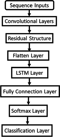
The below figure demonstrates the architecture of the proposed network.
Below is the evaluation results for the proposed methods and ResNet50 on the data set.
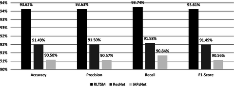
RLTSM is ahead of ResNet and IAPsNet in Accuracy, Precision, Recall, and F1-Score
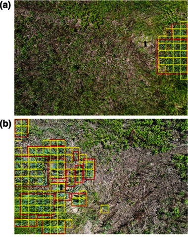
This below figure is an visualization of how the predicted results (outlined in yellow) match the ground truth (outlined in red).
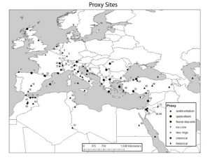
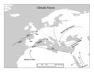
Dr. James Ermatinger’s research on climatic factors during the Roman Optimum (200 BCE – 200 CE)
Interim Dean of UIS’s College of Education and Human Services, Dr. James Ermatinger, is studying the climate throughout the Roman Empire.
Historians have debated the cause of the fall of the Roman Empire for centuries. While climatic change has been stated, it has never been completely studied until recently. This project focuses on the transitional period between the so-called Roman Optimum (200 BCE-200 CE) when the climate was beneficial throughout the Mediterranean and the Late Roman Period when the Empire (350-500 CE) had a beneficial climate again. This transitional period (225-325 CE) witnessed both beneficial and deleterious climate factors and corresponded to the life and rule of Diocletian. Basic questions posed were what was the climate like during this period? Did the climate have noticeable periods of differentiation? Did the beneficial climate of the Roman Optimum lead to the attacks on the Empire due to overpopulation caused by the beneficial climate or did the deleterious climate of the 250’s lead to attacks due to decline in living conditions?
To aid with this research project, the GIS Laboratory designed and developed the maps, shown below, depicting climatic trends.
Mapping for Roses from Kenya: Labor, Environment, and the Global Trade in Cut Flowers, by Environmental Studies Professor, Dr. Megan Styles
In November of 2019, UIS Environmental Studies professor, Dr. Megan Styles, published Roses from Kenya: Labor, Environment, and the Global Trade in Cut Flowers discussing her research on the cut flower trade.

Kenya supplies more than 35 percent of the fresh-cut roses and other flowers sold annually in the European Union. This industry—which employs at least 90,000 workers, most of whom are women—is lucrative but enduringly controversial. More than half the flowers are grown near the shores of Lake Naivasha, a freshwater lake northwest of Nairobi. Critics decry the environmental side effects of floriculture, and human rights activists demand better wages and living conditions for workers. In Roses from Kenya: Labor, Environment, and the Global Trade in Cut Flowers, UIS environmental studies professor Megan Styles presents a rich ethnographic portrait of how this industry shapes Kenyan livelihoods, landscapes, and politics. Using satellite imagery, the UIS GIS lab created a map showing the location of major greenhouse complexes and open-air horticultural farms surrounding Lake Naivasha to help readers understand just how profoundly rose farming has changed this place. Roses from Kenya is available from the University of Washington Press and major book sellers.
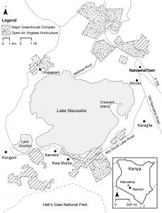
Included in this book is a map created by the GIS Laboratory. The above map shows the location of major greenhouse complexes and open-air horticultural farms near Kenya’s Lake Naivasha, where 70% of the cut flowers exported from the country are grown. It also shows the location of the lakeside “villages” where most farmworkers live.
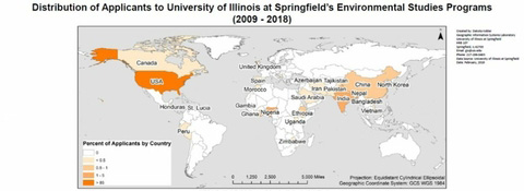
Where do applicants to the Environmental Studies programs call home?
The GIS Laboratory created maps showing where applicants to UIS’ Environmental Studies programs lived between the years 2009 – 2018, to identify geographical patterns among applicants. These data are useful for recruitment purposes. For applicants from the United States, we found the majority of applicants resided in Illinois, followed by California. The majority of our international applicants were from India, Nigeria, Ghana, and China, respectively.